
BPSC · District of Bihar · Bhagalpur division
Bhagalpur: the Silk City where Anga's kings once ruled
- People
- 30,37,766
- Area
- 2,569 km²
- Literacy
- 63.14%
- Sex ratio
- 880
- HQ
- Bhagalpur
- Blocks
- 16
Listen to the podcast · with Ujjwal, 4 min
A friendly chat through the land, the chain of events and every era. In Hindi and English.
Ruins of Vikramshila Mahavihara, Antichak · Jai Anga, CC0
Your mind map
Tap a branch. Tick each fact once it sticks; the rings fill as you learn.
What the region comes here for
Bhagalpur as a hub
Why the villages around Bhagalpur send their children here
Bhagalpur is the education and services capital of a wide belt of eastern Bihar and the Santhal Pargana side of Jharkhand. A student from Banka, Godda or Naugachhia usually takes a bus or train to Bhagalpur for college, coaching, a hospital or a court case. That pull has a history.
Who depends on it: Bhagalpur and Banka districts (the division), the Naugachhia side across the river, Munger, Katihar and Purnia nearby, and Godda, Sahibganj and Dumka in Jharkhand.
- 1
The British made Bhagalpur a revenue district and later a divisional headquarters, so courts, offices and officials gathered here.
- 2
Officials, lawyers and merchants wanted schools and colleges for their children, so T.N.B. College opened in 1883, one of the oldest colleges in Bihar.
- 3
After independence the state placed a university (1960), an engineering college (1960) and a medical college (1971) here, because the colleges and the division HQ were already here.
- 4
Thousands of students from villages moved in, which created lodges, hostels, coaching institutes, libraries and bookshops: a whole student economy.
- 5
The medical college hospital became the referral hospital for the region, and rail, road and the 2001 bridge made Bhagalpur even easier to reach. More people came, and the hub grew.
- T.N.B. College · 1883
Tej Narayan Banaili College, among the oldest colleges in Bihar; now part of the university.
- Tilka Manjhi Bhagalpur University · 1960
Set up as Bhagalpur University in 1960 and later renamed after Tilka Manjhi; its colleges spread across the division.
- Bhagalpur College of Engineering · 1960
One of Bihar's older government engineering colleges.
- Jawaharlal Nehru Medical College and Hospital (JLNMCH) · 1971
Trains doctors and runs the big referral hospital that patients reach from across eastern Bihar and nearby Jharkhand.
- Bihar Agricultural University, Sabour · 2010
Grew out of an agricultural college started in 1908; research behind Zardalu mango and Katarni rice.
- IIIT Bhagalpur · 2017
An Indian Institute of Information Technology set up in public–private partnership.
- Commissioner's office and civil courts
Bhagalpur is the HQ of Bhagalpur division (Bhagalpur and Banka). Appeals, land cases and offices bring people in every day.
- Bhagalpur Junction and Vikramshila Setu · 2001
The railway junction on the Sahibganj loop line (Malda division, Eastern Railway) and the 2001 bridge to Naugachhia tie the region to the city.
🛒 Trade: silk trade from Nathnagar and Champanagar, and wholesale markets for the villages around
⚡ Power: NTPC Kahalgaon (2,340 MW) supplies power to Bihar and other eastern states
🛕 Pilgrimage: Sultanganj is the starting point of the Shravani Mela kanwar route to Deoghar
Exam angle: A Mains-style point: administrative centres become education and health hubs, because officials, courts and early colleges come first and everything else follows. Bhagalpur shows this cause and effect clearly.
Bhagalpur in 8 numbers
Census 2011 · rank among the state's districts
History
From Karna's kingdom to the first revolt against the Company
- Epic age
Anga, the kingdom of Karna
In the Mahabharata, Duryodhana makes Karna the king of Anga. The region around Bhagalpur is still called Anga, and its language is Angika.
Remember Anga = Bhagalpur–Munger region; language Angika
- 6th c. BCE
MahajanapadaChampa, capital of Anga Mahajanapada
Anga was one of the sixteen Mahajanapadas, with its capital at Champa near today's Bhagalpur. Buddhist texts count Champa among the six great cities of the Buddha's time. Bimbisara of Magadha annexed Anga.
Remember Anga capital Champa; annexed by Bimbisara (Magadha)
- Ancient
JainChampapuri, sacred to Jains
Champapuri (Champanagar) is linked with Vasupujya, the 12th Tirthankara, and is a Jain pilgrimage site.
Remember Champapuri → Vasupujya, 12th Tirthankara
- c. 500–700 CE

Jononmac46 · CC BY-SA 3.0 The Sultanganj Buddha
A metal Buddha over 2 m tall, cast around the 6th–7th century, was dug up at Sultanganj in 1861–62 while the railway was being built. It is now in the Birmingham Museum and Art Gallery, UK.
Remember Sultanganj Buddha → Birmingham Museum (UK)
- c. 800 CE
Jai Anga · CC0 PalaVikramshila Mahavihara is founded
The Pala king Dharmapala founded Vikramshila at Antichak, near Kahalgaon. It became a great centre of Vajrayana Buddhism, a rival and partner of Nalanda.
Remember Vikramshila → Dharmapala (Pala dynasty) → Antichak, Kahalgaon
- 1042 CE
Atisha Dipankara goes to Tibet
Atisha Dipankara Shrijnana, a leading teacher at Vikramshila, travelled to Tibet and helped revive Buddhism there.
Remember Atisha: Vikramshila → Tibet
- c. 1200 CE
Destroyed by Bakhtiyar Khalji
Around 1200, the armies of Bakhtiyar Khalji destroyed Vikramshila, as they did Nalanda. Its ruins were excavated by Patna University (1960–69) and the Archaeological Survey of India (1972–82).
Remember Excavation: Patna University 1960–69, ASI 1972–82
- 1784–85
RevoltTilka Manjhi's rebellion
Tilka Manjhi led the hill people of the Rajmahal area against the East India Company. In 1784 he attacked the Bhagalpur Collector Augustus Cleveland, who later died. Tilka Manjhi was hanged at Bhagalpur in 1785.
Remember Tilka Manjhi vs Cleveland 1784; hanged 1785
- 2001
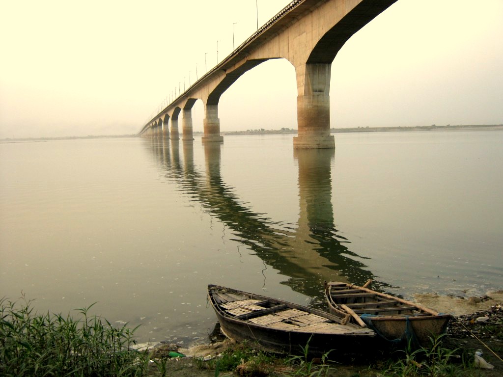
Aquib Haque · Public domain Vikramshila Setu opens
A road bridge of about 4.7 km across the Ganga joined Bhagalpur with Naugachhia on the north bank.
Remember Vikramshila Setu ≈ 4.7 km, Bhagalpur–Naugachhia
Geography
Cut in two by the Ganga, and home to its dolphins
The Ganga splits the district
The Ganga flows west to east through Bhagalpur. Most of the district lies south of the river; the Naugachhia subdivision lies north of it, in the low Kosi plains that flood often.
Remember South of Ganga: Sadar, Kahalgaon. North: Naugachhia (Kosi plain)
Rivers to remember
Ganga, Kosi (north), and the Chandan, which comes from Jharkhand through Banka and joins the Ganga near Bhagalpur.
Remember Ganga · Kosi · Chandan

Kukil Gogoi · CC BY-SA 4.0 SanctuaryVikramshila Gangetic Dolphin Sanctuary
Declared in 1991, it protects about 50 km of the Ganga between Sultanganj and Kahalgaon. It is the only protected area in India set up for the Gangetic dolphin, which became India's national aquatic animal in 2009.
Remember 1991 · Sultanganj–Kahalgaon · ~50 km · national aquatic animal 2009

Deepak Kumar Sharma · CC BY-SA 3.0 The rocks of Kahalgaon
Near Kahalgaon, small rocky hills rise out of the Ganga, a rare sight on the flat plain. Bateshwar Sthan stands on a hill by the river.
Neighbours
Munger and Khagaria to the west, Madhepura, Purnia and Katihar to the north, Banka to the south, and Jharkhand's Godda and Sahibganj to the south-east.
People & society
The land of Angika, Manjusha and the tale of Bihula
Society in numbers (%)
Gender literacy gap: 15.4 percentage points
People by religion
- Hindu 81.9%
- Muslim 17.7%
- Christian 0.1%
- Other / not stated 0.3%
Angika, the language of Anga
Angika is the everyday language of the Bhagalpur region. Hindi, Urdu and Maithili are also spoken.
Remember Bhagalpur ↔ Angika
Women and literacy
Bhagalpur's sex ratio (880) was the second lowest in Bihar in 2011, after Munger, while its literacy was above the state average. Look at the gap between male and female literacy in the chart.
Remember Sex ratio 880 (Bihar 918); literacy 63.14% (Bihar 61.80%)
Economy
The Silk City, its mangoes and its power plant
SilkTussar silk of Bhagalpur
Bhagalpur is called the Silk City. Handloom weavers in Nathnagar, Champanagar and nearby areas weave tussar (tasar) silk into the famous Bhagalpuri saris and fabrics.
Remember Silk City · tussar silk · Nathnagar weavers
GI tagZardalu mango
A fragrant, light-yellow mango of Bhagalpur that received a Geographical Indication tag.
Remember Zardalu mango → Bhagalpur (GI)
GI tagKatarni rice
A short-grain aromatic rice of the Bhagalpur region, also GI-tagged.
Remember Katarni rice → Bhagalpur (GI)
EnergyKahalgaon Super Thermal Power Station
NTPC's coal-based plant at Kahalgaon has a capacity of 2,340 MW, one of the largest in eastern India.
Remember NTPC Kahalgaon · 2,340 MW · coal
Bananas of Naugachhia
The fertile Kosi–Ganga land around Naugachhia is a major banana-growing belt of Bihar.
Sectors at a glance
Farms feed most families, looms give the city its name
How people earn a living
9.8 lakh workers, 32.4% of all people
- Cultivators 13.7%
- Farm labourers 48.3%
- Household industry 6.1%
- Other (industry, services, construction, trade) 31.8%
Farming
Paddy, wheat and maize are the main crops, with bananas and mangoes as cash crops. Nearly half of all workers were farm labourers in 2011.
Handloom and MSMEs
Silk handloom and powerloom units are the biggest small-industry cluster. This shows up in the 'household industry' share of workers.
Power and education
NTPC Kahalgaon, Tilka Manjhi Bhagalpur University and Bihar Agricultural University at Sabour (set up in 2010) are big employers.
Remember Bihar Agricultural University → Sabour (2010)
Schemes & development
From a 2011 baseline to a Smart City
What homes had in 2011 (% of households)
This is the 2011 baseline. Schemes like Saubhagya, Ujjwala, Swachh Bharat and Har Ghar Jal came to close exactly these gaps.
UrbanSmart Cities Mission
Bhagalpur was picked for the Smart Cities Mission in 2016, one of Bihar's smart cities with Patna, Muzaffarpur and Biharsharif.
Remember Bihar smart cities: Bhagalpur, Patna, Muzaffarpur, Biharsharif
EcologyProject Dolphin
Announced in 2020 to protect river and ocean dolphins. The Vikramshila sanctuary stretch is its best-known river site in Bihar.
Read the baseline chart
The chart above shows how few homes had electricity, latrines, tap water or LPG in 2011. Mains answers on Saubhagya, Swachh Bharat, Har Ghar Jal and Ujjwala start from these numbers.
Art & culture
A love story painted on boxes of jute and bamboo

Biharpro7252 · CC BY-SA 4.0 Folk artManjusha art
Manjusha is the folk painting of Bhagalpur. It tells the story of Bihula, who brought her husband Bala Lakhendra back to life after a snake sent by goddess Mansa (Bishahari) killed him. It uses bold outlines and mainly pink, green and yellow.
Remember Manjusha → Bihula–Bishahari tale → Bhagalpur
Bishahari Puja
In August, Bhagalpur worships Mansa (Bishahari), the snake goddess of the Bihula story. Manjusha boxes are made for this festival.
Places to know
Five places, five exam questions
Jai Anga · CC0 ASIVikramshila ruins, Antichak
A large cross-shaped stupa in the middle of a square monastery with rows of monks' cells.

Biharpro7252 · CC BY-SA 4.0 Ajgaibinath, Sultanganj
A Shiva temple on a rock in the Ganga. In the month of Shravan, kanwariyas fill Ganga water here and walk about 105 km to Baba Baidyanath Dham in Deoghar (Jharkhand).
Remember Shravani Mela: Sultanganj → Deoghar ≈ 105 km
Champanagar
Old Champa: Jain temples of Vasupujya and the weavers' quarter.
Aquib Haque · Public domain Vikramshila Setu
The 4.7 km bridge that links the two halves of the district.
Deepak Kumar Sharma · CC BY-SA 3.0 Kahalgaon and Bateshwar Sthan
Rocky islets in the Ganga, a hilltop temple and the NTPC power plant nearby.
Personalities
A rebel, a novelist and a film star
Tilka Manjhi (c. 1750–1785)
Often called the first Adivasi rebel against British rule. Tilka Manjhi Bhagalpur University is named after him.
Atisha Dipankara
The Vikramshila scholar whose journey to Tibet in 1042 renewed Buddhism there.
Sharat Chandra Chattopadhyay
The Bengali novelist of Devdas spent much of his boyhood in Bhagalpur at his maternal grandfather's home.
Ashok Kumar
The Hindi film legend was born in Bhagalpur in 1911.
Memory cards
Say the answer out loud before you flip.
Quick quiz
Exam-style questions on this district.
Question 1/5 · 0 right
Vikramshila Mahavihara was located at present-day
Keep exploring
Sources
- Census of India 2011: A-01 (area, households), Primary Census Abstract and Houselisting tables, Office of the Registrar General & Census Commissioner
- District Bhagalpur, Government of Bihar (official district website)
- Archaeological Survey of India: Vikramshila excavated site, Antichak
- Geographical Indications Registry, Government of India (Zardalu mango, Katarni rice)
- Ministry of Environment, Forest and Climate Change: Vikramshila Gangetic Dolphin Sanctuary; Project Dolphin
- NTPC Limited: Kahalgaon Super Thermal Power Station
- Smart Cities Mission, Ministry of Housing and Urban Affairs
- Birmingham Museums Trust: the Sultanganj Buddha
- District boundaries: DataMeet India, Census 2011 districts (CC BY 2.5 IN)
Photo credits
- Ruins of Vikramshila Mahavihara, Antichak: Jai Anga, CC0, Wikimedia Commons
- The Sultanganj Buddha, now in Birmingham: Jononmac46, CC BY-SA 3.0, Wikimedia Commons
- Vikramshila Setu over the Ganga: Aquib Haque, Public domain, Wikimedia Commons
- A Ganges river dolphin: Kukil Gogoi, CC BY-SA 4.0, Wikimedia Commons
- The rocky islets of Kahalgaon from Bateshwar hill: Deepak Kumar Sharma, CC BY-SA 3.0, Wikimedia Commons
- Ajgaibinath temple, Sultanganj: Biharpro7252, CC BY-SA 4.0, Wikimedia Commons
- Bihar's map drawn in the Manjusha style: Biharpro7252, CC BY-SA 4.0, Wikimedia Commons
- "The Rocks of Colgong", a colonial-era print of Kahalgaon: George Hunt after Charles Ramus Forrest (British Library), Public domain, Wikimedia Commons
- Behula and Lakhinder at the Manasa temple, Champanagar: Jai Anga, CC0, Wikimedia Commons
- Tilka Manjhi: Pinakpani, CC BY-SA 4.0, Wikimedia Commons
- NTPC Kahalgaon power station: Dhanoaprabha, CC BY-SA 4.0, Wikimedia Commons
Facts checked 15 Nov 2026. Districts are shown with their 2011 Census boundaries.